
Attendees discuss one option for the new Southeast Boulevard.
A big crowd attended the District of Transportation’s Feb. 21 meeting on the Barney Circle-Southeast Boulevard Transportation Planning Study. As with the Penn-Potomac intersection study, the city is seeking federal funds for the Barney Circle-SE Blvd project and must complete an environmental assessment. The Feb. 21 meeting was the first of three planned public meetings on the project.
Here are the highlights:
- The meeting began with a brief presentation by Sanjay Kumar of DDOT and Karl Kratzer of consultant CH2MHill. As with Penn-Potomac, DDOT has hired CH2MHill to manage and complete the study. The presentation outlined the goals of the larger Anacostia Waterfront Initiative and provided a timeline for the project.
- Attendees were divided into smaller working groups with DDOT or CH2MHill facilitators. Each group was asked to provide answers/feedback on the following four questions related to the Southeast Boulevard. I roamed from group to group and heard the following answers:
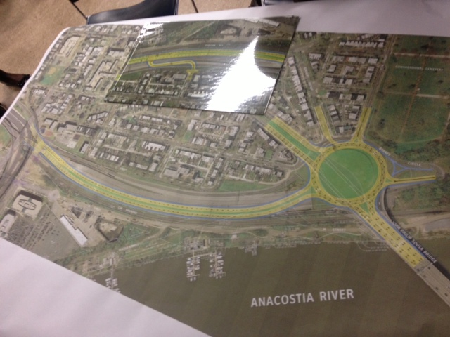
- Where is the best connection from the neighborhood to the Southeast Boulevard? 13th, 14th and/or 15th Streets SE? Most groups seemed to support connecting all three streets to the boulevard as a way to distribute traffic along multiple routes. However, there were a number of attendees who live on or near 13th, 14th & 15th south of Pennsylvania Avenue who preferred no connections between these streets and the boulevard. While I understand the concerns of these residents, I’m also concerned that a boulevard without connections and stop lights is really just another freeway separating the neighborhood from the waterfront.
- How is L Street SE incorporated into the Southeast Boulevard? Integrated completely, separated slightly or completely separate? I didn’t hear any support for fully integrating the currently quiet, residential L Street SE with the boulevard. There was more support for separating the two with green space and bringing the boulevard up to grade with L Street.
- How should the city use the space created underneath the elevated Southeast Boulevard? DDOT and CH2MHill asked whether attendees would prefer a multi-modal transfer facility/bus parking lot or a commuter parking lot under the elevated freeway. My sense is that a majority of attendees preferred the former.
- In addition to pedestrian and bike connections, should the project attempt to provide a vehicle connection between M Street SE and the new SE Boulevard. I heard some support for this idea, but most groups emphasized increasing pedestrian and bike access to the waterfront. Of course, the CSX railroad tracks and the difference in grade between the proposed boulevard and waterfront are obstacles to both goals.
- DDOT did not specifically ask for feedback on the other major portion of the project – the transformation of Barney Circle into a full traffic circle. I hope there will be more discussion about the circle at the next public meeting.
- A few groups did raise concerns about plans for “Park Drive,” a proposed roadway connecting Independence Avenue SE with the new Barney Circle via the Anacostia Waterfront. As I’ve mentioned in previous posts, Park Drive is a bad idea, particularly since it would cut off mixed-use development at Reservation 13 from the waterfront.
DDOT plans to hold the next public meeting on the project in the spring. At that meeting, attendees will review alternatives and provide feedback. ANC 6B’s Transportation Committee also plans to discuss the project on March 6.
Thanks to everyone who came out and participated in the meeting. And a big thanks to Principal Marcus and Payne Elementary School for playing host to both the Penn-Potomac and Barney Circle meetings.
Please post your comments/feedback/questions below. And if you want to be added to the project e-mail list, send an e-mail to barneycircle@prrbiz.com.

One option under consideration would completely integrate L Street SE and the new SE Blvd.

A second option would separate L Street and the SE Blvd but connect at 13th, 14th and 15th.
A third option would separate the SE Blvd completely from the neighborhood.

Some thoughts (I wasn’t able to make the meeting, thanks for providing the recap):
In all of the options shown, the proposed SE Boulevard seems wildly out of scale with what would be appropriate. One lane in each direction should be fine. The idea is presented as a ‘grand urban boulevard,’ but all of the design alternatives look a lot more like a typical suburban arterial.
I very much like the idea of re-connecting the grid of streets, but find the options presented to do so underwhelming. In any of the images shown above, you would gain some ‘green space’ that would be largely useless and trapped in a roadway median. I would much rather see the extension of the grid as the driving factor, and creating new blocks of the city. Those blocks should then be developed. This would add to the city’s tax rolls, provide more development within walking distance of a Metro station, etc.
I also share the desire to see M St SE connected, to help bridge not just the current freeway trench but also the railroad tracks. Extending the street grid at the elevation of L St SE would require some serious air rights infrastructure (perhaps financed in part by the development rights from the parcels it could ‘create’), but right now the only two connection points to the waterfront (e.g. crossings of the RR tracks) are at 11th St SE and at the new riverwalk bridge. As the crow flies, those two points to cross the RR tracks and access the river are 3/4 of a mile apart!
There is no way to access the water directly from the Sousa Bridge at Barney Circle. Some sort of drecking option that could provide some kind of connection (Ranging from a full-out air rights development deck, complete with new street grid, as proposed on i-395 downtown or over the Union Station rail yard) to a simple pedestrian bridge over the RR tracks at 13th, 14th, and/or 15th would be an improvement.
I think Park Drive is a great idea and need not cut off Hill East from the river, but that is all dependent on how the street is designed and how traffic along it is managed. A suburban-style arterial, as shown for the SE Blvd, would be bad. However, a narrow street, to be connected to the Res 13 street grid as it is built out, could be an asset.
Addtional Discussion here:
DDOT could put tour bus parking on Southeast Freeway
February 25, 2013, http://greatergreaterwashington.org/post/17808/ddot-could-put-tour-bus-parking-on-southeast-freeway/
[…] Pennsylvania Ave SE and east of 11th Street SE voiced concern about plans for DDOT’s proposed Southeast Boulevard. Pointing to the recent Sustainable DC announced by Mayor Vince Gray, residents said that building […]
[…] that the District Department of Transportation would be holding its second public meeting on the Barney Circle-Southeast Boulevard project on Thursday, Nov. 21, 6:30 pm – 8:30 pm at Payne Elementary School (1445 C Street […]
[…] the first public meeting on the project in February, the entire discussion was dominated by questions and concerns about the […]