Last night, the District Department of Transportation (DDOT) presented several concepts for replacing the end of the Southeast Freeway with a boulevard. While it’s supposed to reconnect Hill East to the Anacostia River, all of the designs presented prioritize through traffic instead.
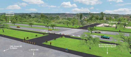
The Southeast Freeway has been a barrier between the neighborhood and the river, but the new 11th Street bridges mean that the spur between 11th Street and Pennsylvania Avenue SE is no longer needed. DDOT would like to replace it with a surface street, called “Southeast Boulevard,” connecting the freeway at 11th Street to Barney Circle.
A standing-room only crowd packed the Payne Elementary School auditorium for DDOT’s public meeting on the Barney Circle-Southeast Boulevard Transportation Planning Study. At the meeting, required as part of an environmental assessment of the project under the National Environmental Protection Act, transportation planners shared design concepts for the project and gathered community feedback.
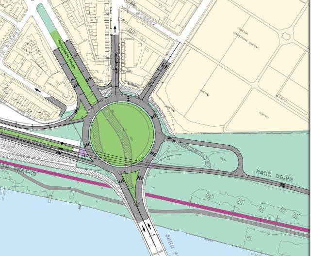
Map on Concept 2. Images from DDOT.
Alternatives for Southeast Boulevard and Barney Circle vary slightly
DDOT planners presented six different options they’re studying for the new street, including a “No Build” option (Concept 1) required as part of the NEPA process that would keep everything as it is today.
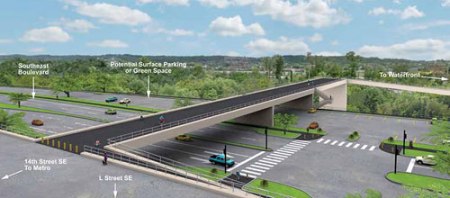
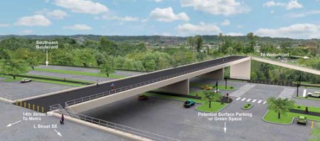
Concept 2 puts Southeast Boulevard on an elevated structure midway between L Street SE and the existing CSX railroad tracks. The boulevard would be on the same level as L Street, with green space acting as a buffer. Pedestrians and cyclists could access the waterfront by crossing the boulevard at 14th Street SE. DDOT would also build a “multi-modal” parking facility underneath the raised boulevard, with ramps off of the boulevard providing bus and car access to the parking facility.
Concept 2
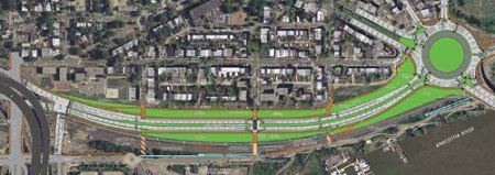
In Concept 3A, Southeast Boulevard would be at grade, below the level of L Street, with surface parking and green space next to it. There would be a foot and bike bridge over the boulevard and another surface lot to provide access to the waterfront.
Concept 3A
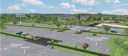
Concept 3B is similar to 3A, except the boulevard is on the same level as L Street. In this case, pedestrians and cyclists would have to cross directly over the 4-lane boulevard and surface parking lot to access the waterfront.
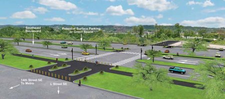
Concept 3B
Concept 4A places the Southeast Boulevard closer to the railroad tracks and away from L Street, with a parking lot in between. The boulevard and parking would be at grade below the level of L Street. Pedestrians and cyclists would access the waterfront via a pedestrian bridge over the parking lots and boulevard.
Concept 4A
Concept 4B is the same, except the boulevard is at the same level as L Street, and pedestrians and cyclists would cross the parking lots and boulevard at 14th Street.
Concept 4B
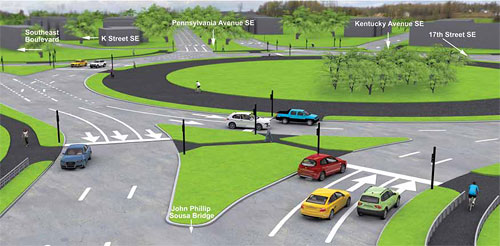
Planners also presented two options on the Barney Circle project, both of which would place traffic signals at the circle.
Option 1 would connect 17th Street, Kentucky Avenue, Pennsylvania Avenue and Southeast Boulevard directly to the circle. Kentucky Avenue would stay a two-way street south of Freedom Way and one-way north of it. K Street would not be connected to the circle, but you could still reach it via Pennsylvania Avenue.
In Option 2, 17th, Pennsylvania and Southeast Boulevard would connect to Barney Circle, while Kentucky Avenue would become a one-way southbound street from H Street to the circle. H Street would become a two-way street, with all-way stop signs installed at 17th & H and 16th, Kentucky and H. K Street would remain one-way, but would connect directly to the circle.
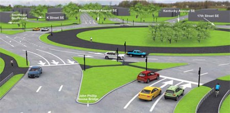
Barney Circle Option 1
These options prioritize through traffic over local connections
All of DDOT’s concepts for Southeast Boulevard have three things in common: they all include a four-lane boulevard, have no connections to local streets, and include some parking element. The agency’s traffic analysis determined that the new street was necessary, connections to local strets would increase cut-through traffic and that there’s a significant need for parking.
The result is concepts that simply recreate what DDOT and the Anacostia Waterfront Initiative are trying to eliminate: a freeway that separates the neighborhood from the waterfront. The extra lanes, lack of signals and additional parking will just attract more drivers to the neighborhood during rush hour.
The designs are especially harmful to 17th Street, where Hill East residents have fought for years to reduce traffic volume and speed. DDOT proposes making 17th Street the only access point to Southeast Boulevard via Barney Circle, making it an alternative for drivers trying to avoid 295 and the 11th Street bridge.
Replace the freeway with a new street grid
If a new street is necessary, a better option is to extend the neighborhood grid by connecting the local streets, 13th, 14th, and 15th, to a two-lane boulevard with stoplights at each intersection. This would make it easier for pedestrians and cyclists to cross at multiple locations and make the boulevard a local street, rather than a freeway.
A two-lane road with multiple signals would attract less traffic, easing but not eliminating some of the pressure on 17th Street SE. Green space could provide a buffer between L Street and the two-lane boulevard. And forget the unneeded parking lots.
On Barney Circle, Option 1 appears to be preferable to Option 2, assuming that DDOT can implement traffic calming measures on Kentucky Ave SE. Option 2 exacerbates current traffic volume problems by attracting more vehicles to 16th, 17th and H streets. Without changes to the Southeast Boulevard portion of the project, both Barney Circle options make the neighborhood worse off.
If the goal of the Anacostia Waterfront Initiative is really “to reduce barriers between neighborhoods and the waterfront parks” and “provide continuous pedestrian and bicycle access along the entire waterfront,” than we need an option that replaces the Southeast Freeway with a new street grid that prioritizes local connections.
What do you think about the proposals? You can send your comments directly to DDOT at barneycircle@prrbiz.com.


 Posted by bflahaven